Microsoft Bing Maps Time Specific Isochrone API
Blog|by Jamie Maguire|22 November 2017
Introduction
We’ve covered the Distance Matrix and Truck Routing APIs in the last articles and now it’s time to turn our attention to the Isochrone API. The API contains many features, some of which allow you to:
- determine optimal travel-times
- determine optimal travel-distance isolines
- factor in multiple transport modes
- take predictive traffic into consideration
- avoid routes that use tolls or highways
With the API, you can easily answer business questions such as –
‘what IT Support technician can arrive onsite with the customer within the next 60 minutes?’
‘where should I live if I don’t want to drive more than 60 minutes to the office?’
The API can provide this functionality by using “isochrones” and gives business more control over their fleet management operations and journey planning.
For the curious, an isochrone is a line drawn on a map which connects points at which something happens or arrives at the same time (side note – isochrones have been used in transportation planning since 1887 or earlier!).
The Isochrone API
The Isochrone API and its complexity have been packaged up in an easy to consume REST endpoint which has been designed to support customisable parameters. These are some of the attributes that can be supplied to the isochrone API:
- start point
- routeMode (driving [default], walking or transit)
- culture
- route avoid
- max distance
- depart time
- max time
With these attributes, you simply construct the request and submit them to the Isochrone API endpoint which will then generate an array of latitude/longitude points that describe the isoline. With the theory out of the way, let see how we can consume the API.
Performing a calculation and consuming the API
Consuming the Isochone API is straight forward, you construct http requests with the required parameters and submit them to the API endpoint. Note – you need a subscription key prior to submitting any requests to the Isochrone API. You can get a subscription key here.
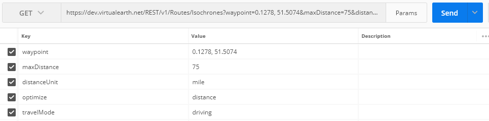
Consider the following example:
A take-away business has a fleet of electric cars used to deliver food to their customers, each vehicle has a maximum range of 150 miles on a fully charged battery.
The business wants to be able to determine which customer locations the vehicles can reach and return to base without having to stop and recharge the vehicle.
To help solve this problem we can supply the following parameters to the Isochrone API:
- maxDistance: 75 miles (150 miles round trip)
- distanceUnit: mile
- optimize: distance
- travelMode: driving
- waypoint: Delivery company’s shop latitude/longitude (London)
Constructing the request
In the following screen shot, you can see a sample request to the endpoint (using Postman):
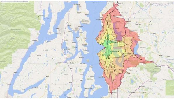
When submitted to the Isochrone API, a collection of isochrone polygons is returned which detail latitude/longitude pairs where electric vehicles can fulfill deliveries as per our parameters and constraint of a 150-mile round trip.
The Response
In the following screenshot below, you can see a subset of the JSON response that gets returned by the Isochrone API.

This collection of coordinates can then be used to overlay polygon areas on a BING Map, thereby giving businesses rich visualisations as illustrated in the screenshot below:

Image: Microsoft
For reference, the entire URL used in the PostMan request:
| https://dev.virtualearth.net/REST/v1/Routes/Isochrones?waypoint=0.1278, 51.5074&maxDistance=75&distanceUnit=mile&optimize=distance&travelMode=driving&key=AkiMgDiiHwTQ5Isj6y-pr20vrV5ve8IIoVXLDDMAXsDglmobQaUupD9w12Yjzfqp |
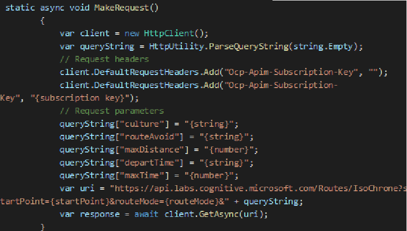
Easy Integration
Consuming the API in a programming language of your choice is straight forward. Thereby making it easy for developers to integrate the Isochrone API with existing software products:
Other Applications
We’ve just ran through one example where the Isochrone API can be helpful. Other use cases where isochrones can be used include might be:
Stolen Vehicle Recovery
Where could a vehicle have traveled to since it was stolen?
Recreation
Where could I walk to within 30 minutes of where I am?
Emergency Services Planning
Where could an emergency vehicle travel to within 5, 10, and 15 minutes?
Marketing
Identify catchment areas for the placement of consumer ads (proximity marketing), e.g. the target audience may live within a 15-minute walk of a local park.
Recruitment
Isochrones can help recruitment agencies “surface” locations when looking to fill location specific roles, thereby allowing recruitment agents to pin-point to the postcode, where prospective candidates should ideally live.
Resources
The following links contain further information regarding the Isochrone API and a demo application that allows you to see it in action:
Demo Application
http://bmlabs.azurewebsites.net/v8-Isochrone/index.html
Detailed Feature Overview
https://www.microsoft.com/en-us/maps/isochrone
https://query.prod.cms.rt.microsoft.com/cms/api/am/binary/RE1GJvi
Isochrone API Endpoint, Parameter Reference and Code Samples
Summary
You can experiment with the Isochrone API, get an understanding of the APIs and parameters as well trial out some of the other use cases for the technology.
From a developer’s perspective, these APIs and services have been packaged up into easy to use APIs that can integrate seamlessly with your existing business solutions.
Want to learn more about the Isochrone API? Please call the Grey Matter mapping specialists:
+44 (0)1364 655 133 or email: [email protected]