Azure Maps Creator and Azure IoT
Blog|by Mary Branscombe|25 August 2020

Making a map of a building isn’t just about digitising the floorplan: with digital twins and sensors, you can get a dynamic system that maps, monitors and manages the flow of the physical processes that happen in your business.
Rather than thinking about IoT as being about the devices and the sensors that make them ‘smart’, a smart building will have spatially aware systems that go beyond indoor maps to include real world context and the ability to take action or discover insights rather than just get an alert.
That’s why Azure Maps Creator is part of Azure IoT as well as Azure Maps: enabling you to create a relationship between maps (which don’t change often) and spatial data (which does).
Watch the recording of our Azure Maps webinar, The Location of Things: Smart Cities with Azure Maps, IoT and Digital Twins over on our YouTube channel, link here

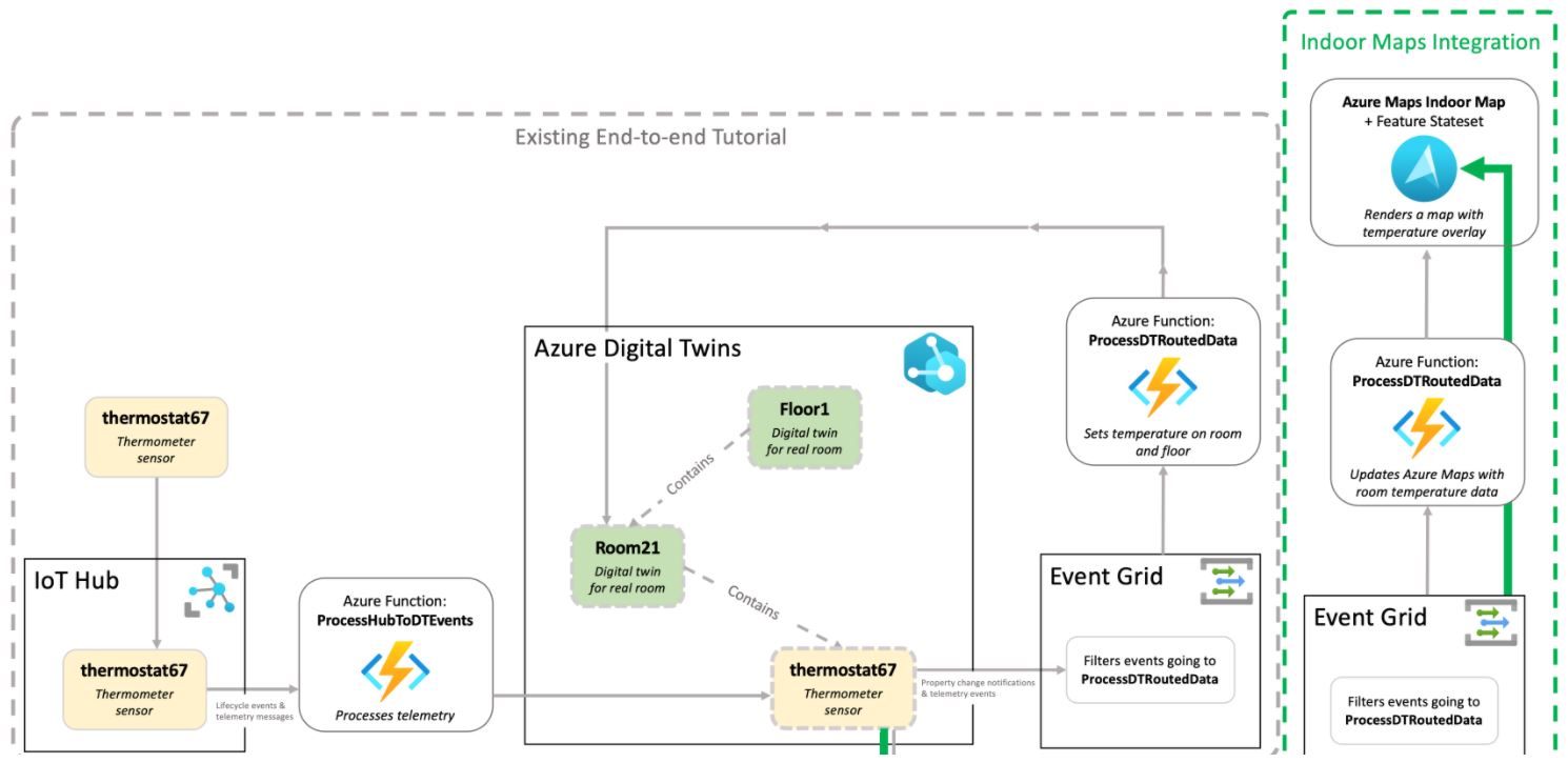
A view of Azure services in an end-to-end scenario, highlighting the
Indoor Maps Integration piece. Source: Microsoft
“IoT is appealing for this because it’s no longer the traditional way where some user needs to enter the data manually – like something has been checked in or something has been checked out – and they have to keep the data as fresh as they possibly could. Instead it’s connected with live systems and the power of cameras and sensors. AI is enabling that, so that the process and the volume of data that come in and feed a map is radically different from what we could have imagined just five years ago,” explains Roberto Lucchi, Senior Program Manager on Azure IoT.
IoT data and maps
When you’re mapping an indoor space like a warehouse or factory, some of the data you use is about the physical and spatial aspects, like the footprint that a piece of machinery occupies, but some of it is about the implications of where that machinery is or what it does. “It can be the safety area around the machine, or it can be areas that define the path a robot can follow; as industry and factories become more modern, the use of automated systems to move heavy objects and keeping people safe is bringing new requirements for utilising space.”
Watch the recording of our Azure Maps webinar: “The Location of Things” on our YouTube channel here
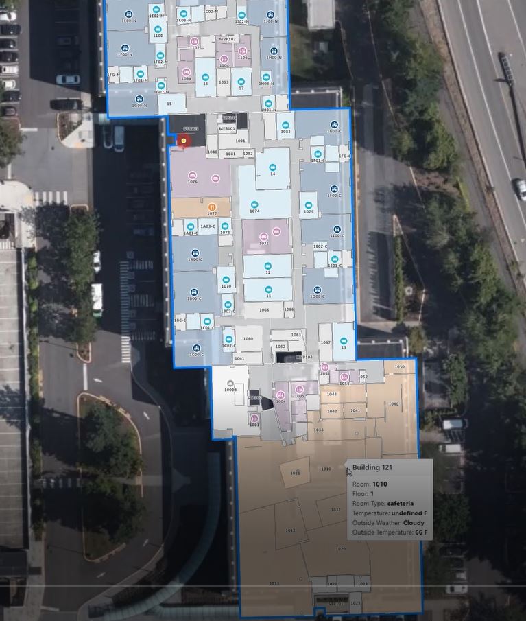
The Azure Maps APIs let you connect multiple data sources to your private maps. Data in the Azure Digital Twins service stores the graph of the relationships between IoT devices and sends telemetry to different endpoints. Link that to an indoor map made with Azure Maps Creator through an Azure Event Grid topic and an Azure Function that reads the update messages and can update information overlaid on the map (like the current temperature or whether there are people in the room) as well as taking actions (like turning off the lights and turning down the heating if a room or an entire floor is empty).

Source: Microsoft
Linking that same information to Power BI lets you gather data and use analytics to plan for how your business utilises the space it’s paying for, which can have a much bigger impact on costs (and corporate sustainability goals) than whether the lights are left on at night.
Spatial intelligence and IoT
What businesses spend on utilities, rent and payroll typically follow a 3-30-300 rule. Utilities cost around $3 per square foot per year (of which more than $3 goes on energy), while the lease for that physical space is around $30, but the cost of an employee in a store, factory or office space is more like $300 (averaged out per square foot per year).
Traditionally, organisations have tried to save money by saving on energy bills, and spatial intelligence from maps and IoT can certainly help there, Lucchi says. But understanding how you use the space you’re paying $30 a square foot for every year can have more impact.
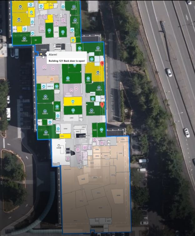
“There are standard formulas like ‘I have so many office employees, I need x square footage for each of them’, but you don’t really know how they’re using the space. You don’t know if they like to work together in an open space, you don’t know if they’re actually in the office or if they’re travelling or working from home.” Using IoT to understand what’s happening in a particular space might mean you don’t need as much space as you thought because not everyone is in the office all the time (something that’s of particular importance as staff either return to the office or shift to longer-term remote work in the current situation).

Source: Microsoft
And because of the three orders of magnitude in the cost of space, using spatial intelligence to organise the space you have to make employees more efficient and productive is a still bigger opportunity than saving money by paying for less space. Take an occupancy sensor in meeting rooms. “There are so many meeting rooms that are booked, but not occupied, because maybe everybody’s joining remotely, or that meeting got cancelled, or verbally cancelled but the room is still showing as booked. The ability to say ‘there should be a meeting right now but it’s ten minutes past the beginning of the meeting and the occupancy sensor tells me nobody is here so I’m going to mark it as free’ is one thing. But then a space utilisation manager can look at this and say, ‘you know, there are trends here’.”
As open workspaces became more common, having more smaller meeting rooms might have given staff the space they needed, better than a few large rooms. It also matters where those meeting rooms are and how long staff spend ‘commuting’ between different meeting rooms because that can add up over the course of a week.
Indoor maps for productivity and efficiency
Being able to see which meeting rooms are available to have a conversation without walking around to see which ones are empty even though they’re booked saves time individually; changing the office layout to reflect actual meeting habits saves time and money more broadly.
Just being able to find what you need makes people more productive. “For me as the customer of a retail store being more productive could mean I’m more entertained, or I spend less time on shopping because I can find everything on my shopping list without stress. In the office it could be I know where the printer is that I sent my printout to, or I know where the fire extinguishers are. Or I know where my colleagues are, not just because they’ve been assigned to a particular office, but maybe because their laptop telemetry says ‘actually, Ricky isn’t in his office, he’s actually in this other space’ and if I happen to be close I can take advantage of that to have a chat in person.”
Think of IoT as an automated observer and there are a lot of opportunities to use Azure Maps Creator to improve the ‘indoor universe’, Lucchi suggests.
Our Azure Maps webinar recording on our YouTube channel here
Azure Maps Creator documentation is available on the Microsoft website
Azure Maps indoor maps and Azure Digital Twins documentation is available here
To get started with Azure, or for more information about Azure Maps and Azure IoT, contact the Grey Matter mapping team: [email protected] or +44 (0)1364 655 133.
Contact Grey Matter
If you have any questions or want some extra information, complete the form below and one of the team will be in touch ASAP. If you have a specific use case, please let us know and we'll help you find the right solution faster.
By submitting this form you are agreeing to our Privacy Policy and Website Terms of Use.
Mary Branscombe
Mary Branscombe is a freelance tech journalist. Mary has been a technology writer for nearly two decades, covering everything from early versions of Windows and Office to the first smartphones, the arrival of the web and most things in between.
Related News
Bing Maps key no longer valid? Here’s what to do about disabled basic keys
Experiencing a Bing Maps API error? Learn why Microsoft disabled Basic Keys, what it means for your app, and how to upgrade to a supported Bing Maps license.
Design smarter, not harder with Adobe Express
Wed 9 July 2025 3:30 pm - 4:30 pm BST
No design team? No problem Join us for an exclusive webinar to discover how Adobe Express can help transform the way your teams create, collaborate and scale content. Whether you’re an SMB or starting to scale your operations, you can...
The state of ransomware in 2025
Wondering about the current causes and consequences of ransomware and how it might affect you? Sophos has collated that info for you. They’ve recently released the latest version of their handy State of Ransomware report which reveals the reality of...
ESET proudly sponsors Tech Summit
We recently announced our revamped partner event in September – Tech Summit. And we’re delighted to announce our first sponsor, ESET, has been confirmed. Why you should visit the ESET stand Security is very important Ransomware affects 59% of organisations,...