Azure Maps for IoT and Smart Cities
Blog|by Mary Branscombe|13 April 2021

Understanding and operating an environment as complex and interdependent as a city needs a lot of data and maps are a fundamental tool for making sense of that for planning and operations.
What is Azure Digital Twins?
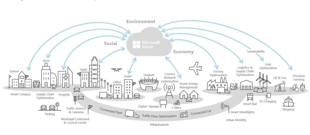
Digital Twins and sensors can help you create a smart building; scale that up with IoT and digital twins for factories, farms, hospitals, schools, energy grids, roads, railways, vehicles, stadiums and other infrastructure and we could create smart cities that are safe, accessible and resilient, because the key systems are interconnected. Although few places have moved beyond pilots or specific initiatives, more cities are beginning to use sensor data, digital twins, automation and control systems for urban planning, visualisation, simulation of the urban environment, connecting citizens to services, and operating city infrastructure through city management dashboards.
Mapping and geolocation
Mapping and understanding location and how weather, transit, real-time traffic and other environmental data impact it is a key part of the smart city opportunity. Which is why Microsoft’s Smart City IoT services integrate closely with Azure Maps – which includes real-time traffic, weather data and forecasts and transit information from Moovit that you can combine with your own sensor data.

and things is unlocking new opportunities, creating new efficiencies, and improving
public and private spaces. Source: Microsoft
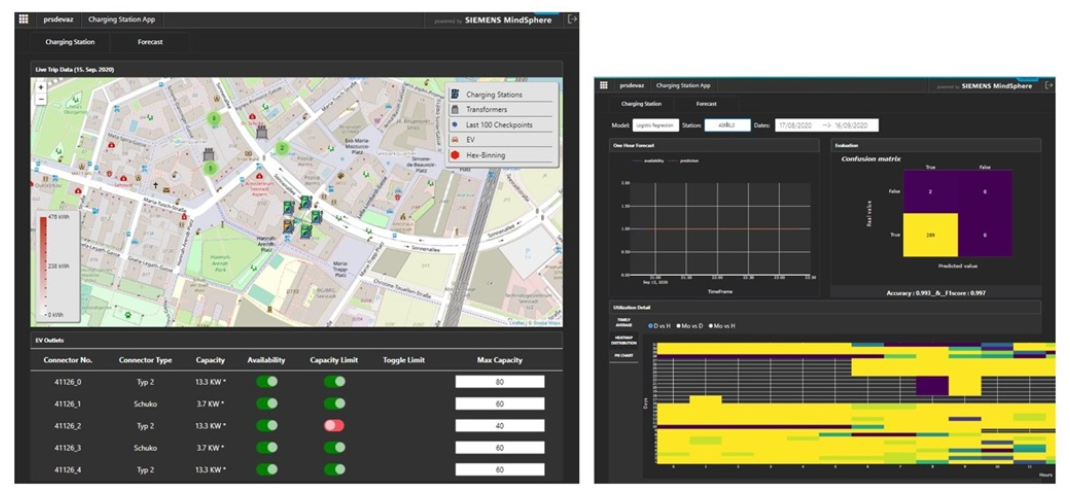
Even simple mapping features like being able to find electric vehicle charging locations with the right kind of connector for your vehicles simplifies route planning for businesses and city departments. Add in live data from IoT sensors to the map visualisation and the charging stations that have availability or the warehouses with a necessary part in stock can change colour or animate so they’re easier to find.
Watch the recording of our Azure Maps webinar, The Location of Things: Smart Cities with Azure Maps, IoT and Digital Twins. Link to the recording on our YouTube channel here
If you need to look at a lot of sensors in the same location, Azure Maps can cluster them so that you can zoom in to see a single reading or see them logically grouped as you zoom out.
Analysing the 12,000 traffic accidents in Madrid in 2020 using AI highlighted how the complexity of an environment can add to driver distraction: where the street furniture is placed, where cars are parked, even how intrusive ad billboards are. That’s the kind of information urban planners and emergency services can use to predict accident blackspots or improve the urban space to avoid them.
IoT and predictive modelling
Combining IoT sensor data and location can unlock insights you couldn’t find otherwise. Simulating traffic flows around big sporting events can help with traffic management plans. Switching roads to one way can help people who are leaving the game drive away more quickly to clear the congestion, but if public transit and ride sharing are popular, some of the roads to the stadium will need to let buses and taxis in to pick people up.
One of the areas where IoT is having the biggest impact already is predictive modelling for when equipment like lifts and escalators are likely to break down. Location data is important for efficiently scheduling field service, using geospatial analytics to determine which engineers are in the right place with the right parts, but large retail locations like shopping centres can take the analysis a step further by looking at the layout of the entire facility to find patterns. If one escalator breaks down more frequently, is it a design problem or is it that it's just the one used by more visitors? Is that because of the stores it accesses, or because it’s the main escalator from the most popular parking spaces and doing some maintenance work on the car park that’s used less would balance the load and lead to fewer failures?
It's also important to include all the local infrastructure in planning decisions and to use sensor and city data together to understand patterns and habits.
When Louisville, Kentucky started building bike lanes to reduce car traffic they soon discovered they needed safety lanes to protect the cyclists from accidents. Encouraging bike rentals and ride sharing on a street known for its college bars helped reduce drunk driving and stop local residents complaining that all the parking spaces were full. But the bike rental companies also had to modify their app to stop riders leaving their bikes in front of the nearby centre for the blind; now the meter on the rental bikes won’t turn off unless they’re in the designated parking area.
On a rather larger scale, port authorities are often still using paper maps of their facilities alongside the satellite imagery that shows the ships coming into their docks. Digitising what are often private maps and integrating them with public map data, then adding IoT and machine learning to measure the cargo and train a model for managing the containers arriving and departing, lets them build new logistics systems to optimise shipping. In an area with several ports, that might involve re-routing ships a couple of hours out to a different location based on the conditions of the port, or the traffic situation on the roads out of the port.
Integrating and connecting urban data
For any scale of environment, when you need to attach sensor data and make it more useful and more referenceable, maps are a foundational tool.
It's important to use both stationary and mobile sensors, and maps are the obvious way to do spatial intersections and bring in the geometry of where they’re located. Location also simplifies analysing time series data; having the location and time both recorded in sensor logs lets you reference different conditions like air quality and weather alongside data collected from sensors.
The Azure Digital Twins platform (which connects to Azure IoT Hub, Azure Time Series Insights and Azure Digital Maps) lets you model connected environments: on a small scale that can be a building, a factory, a farm, a sports stadium or a university campus. But it also scales up to an entire utility grid, transport infrastructure like railways or an entire city environment.
The managed Azure IoT Central platform includes templates for common local government services like refuse collection (using sensors that report when a bin is nearly full) and monitoring water quality and usage. Cities are also looking for solutions for air quality monitoring, as well as smart streetlights that report failing bulbs and adapt to weather conditions.
Microsoft documentation and resources:
Azure IoT Central Government Solutions
Connected waste management solution
Water consumption monitoring solutions
Get connected to Azure IoT Central
ISVs are building Azure services like Azure Digital Twins into their urban infrastructure tools: Siemens MindSphere City Graph uses the service for modelling urban environments and Bentley’s OpenCities Planner brings real-time IoT data into 3D geometric models of existing and planned urban infrastructure.

Because Azure Maps offers REST APIs, developers can easily connect to the services in their own applications; there is also a web SDK and an Android SDK, with plans for other mobile devices and a future Windows option using Xamarin.
Grey Matter is an Azure specialist with a team of mapping experts who can discuss your use case and get you set up on Azure, Azure IoT and Azure Maps. Contact the mapping team.
Contact Grey Matter
If you have any questions or want some extra information, complete the form below and one of the team will be in touch ASAP. If you have a specific use case, please let us know and we'll help you find the right solution faster.
By submitting this form you are agreeing to our Privacy Policy and Website Terms of Use.
Author
Mary Branscombe
Independent Writing and Editing Professional at Freelance
Mary is a technology journalist with over three decades of experience, regularly contributing to CIO.com, The New Stack, Computer Weekly, The Stack, AskWoody and more. She specialises in Microsoft, authoring two books on Windows 8 and one O'Reilly book on Azure AI services with writing partner, Simon Bisson.
Related News
Adobe Creative Cloud for Teams is retiring for Education
Adobe Creative Cloud for Teams retires for higher education on 31 March 2026.
This is your chance to modernise creativity, collaboration, and compliance across campus. Explore Creative Cloud Pro Plus (Enterprise) and plan a smooth migration that empowers teaching, learning, and research.
We’re exhibiting at Cloud & AI Infrastructure London 2026
4 - 5 March 2026 9:00 am - 5:00 pm GMT
We’re excited to be heading back to London for this year’s Cloud & AI Infrastructure London 2026. Make sure to grab your ticket and stop by our stand D212. We’d love to hear your updates on what’s new in your organisation – the plans and challenges you’re facing in 2026. ...
Cyber security in 2025: What we learned and how to stay ahead in 2026
Why human factors, AI, and compliance will define the next era of cyber defence 2025 was a turning point for cyber security. From headline-grabbing breaches to the rise of AI-driven attacks, businesses faced unprecedented challenges. So, what can you learn – and how can...
Mapping as a security function
Mapping has become a core part of modern security. Azure Maps and HERE give organisations the privacy, governance and geospatial insight they need to protect data, strengthen threat awareness and secure day-to-day operations.