Azure Maps and IoT
Blog|by Mary Branscombe|31 December 2019

If you’re outfitting a smart building with sensors that monitor the environment and help you to detect problems like clogged air filters and burst pipes, avoid wasting money by running the heating when the windows are open, or even use predictive maintenance to know what’s likely to go wrong and address the problem before it happens, you need to know where a specific sensor is. Sensors that change the colour of the light over a parking space when it’s full or empty make it easier for people to park, but if you want to track the flow of traffic or look for spaces that are underutilised to see if you need to make changes, you need to know which sensor is in which parking spot. Or more simply, if you have sensors in commercial devices like refrigerators to warn the field service team about problems like the temperature going up, they need to know which particular unit they need to work on.
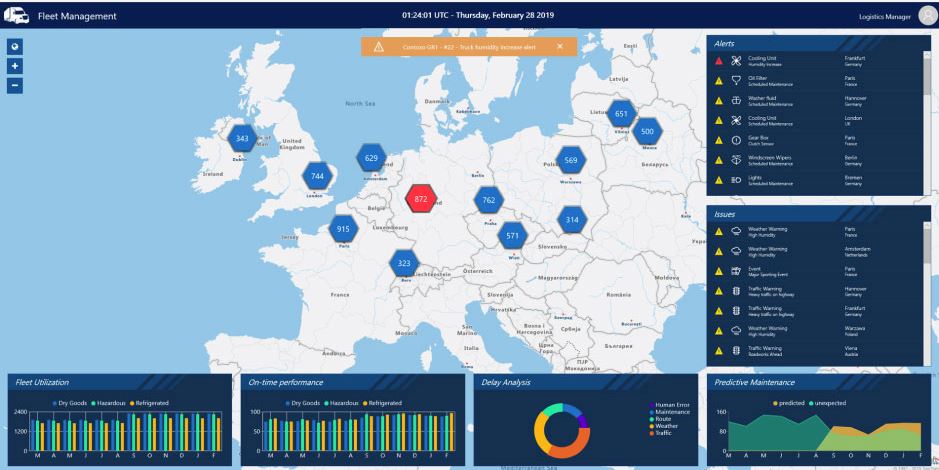
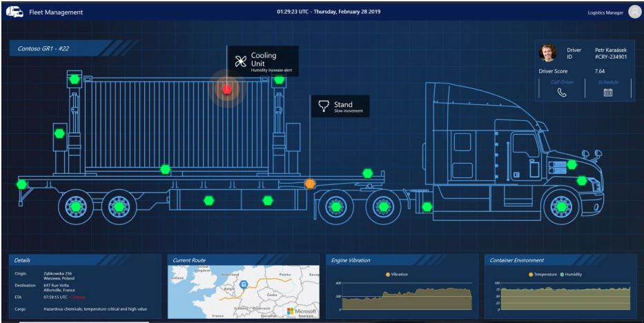
Or say you’re switching to an open office layout with hotdesking and focus spaces, plus bookable meeting rooms: sensors can help you make that more efficient by detecting which spaces are in use and which are available for a meeting. You can even detect if there’s a room that never gets used even when the office is busy – so you can look into what’s wrong with that space and address it. But again, you need to know where the sensors are and be able to show available rooms on a map, with directions, so people don’t waste time looking for the right meeting (or interrupting the wrong meeting).
Register now for our live online Azure Maps webinar: The Location of Things: Smart Cities with Azure Maps, IoT and Digital Twins.
Thursday, 22 April 2021. Presented by Microsoft Senior Technical Program Managers Justine Coates and Miriam Berhane Russom.
On a building site or in a mine, knowing where machinery is can be a safety issue, and there are often dangerous areas on site like holes, ditches and overhead cables: over a quarter of all workplace deaths in the UK are on construction sites. Putting a geofence around those dangerous areas means workers can get an alert before they walk or drive into a dangerous area. The same system can enforce speed limits and keep an audit log of any unsafe behaviour, even a near miss, for accident reports.
A Highway maintenance company in the UK is already using GPS-tagged vehicles and safety vests for job site safety, Azure Maps principal technical program manager Ricky Brundritt explains.
Access Azure Maps geofencing samples on GitHub
Read the tutorial: Set up a geofence by using Azure Maps
Pluralsight course: Getting Started with Azure Maps
“They create geofences around high danger areas like overhanging wires. One of the issues is workers who come onto the site and walk into a dangerous area and they don’t realise until it’s too late, and that’s when an accident happens. Their workers are already wearing a high visibility vest, so they added some IoT sensors and made it a connected safety vest. Now when they enter into one of these geofences, the vest flashes to notify them they’re in a dangerous area. And if they’re driving a vehicle, they also get a notification they’ve entered the area. If a truck comes into one of these areas and it was to continue moving, it might risk hitting low hanging wires and that’s a combination that can be extremely dangerous.”
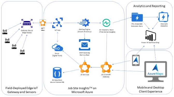
IoT and location data can also save money and help with quality control. You need to control the temperature and humidity when concrete is drying, and to keep workers comfortable; so you need to know where the sensors are as well as where the wet concrete is. It’s a lot more efficient to send someone to turn off the one light that sensors tell you has been left on at the end of the day, than to have qualified construction staff doing a menial task like checking every room just in case any of the lights are on.
Location intelligence in Azure
Azure IoT Hub makes it easy to deploy and manage sensors (if necessary, using Azure IoT Edge gateways on site), and to route the measurements coming from them into cloud storage and analytics. Pair that with the Azure Digital Twins service to model the equipment and the physical space, then add Azure Maps to get spatial intelligence that brings together business logic and topology.
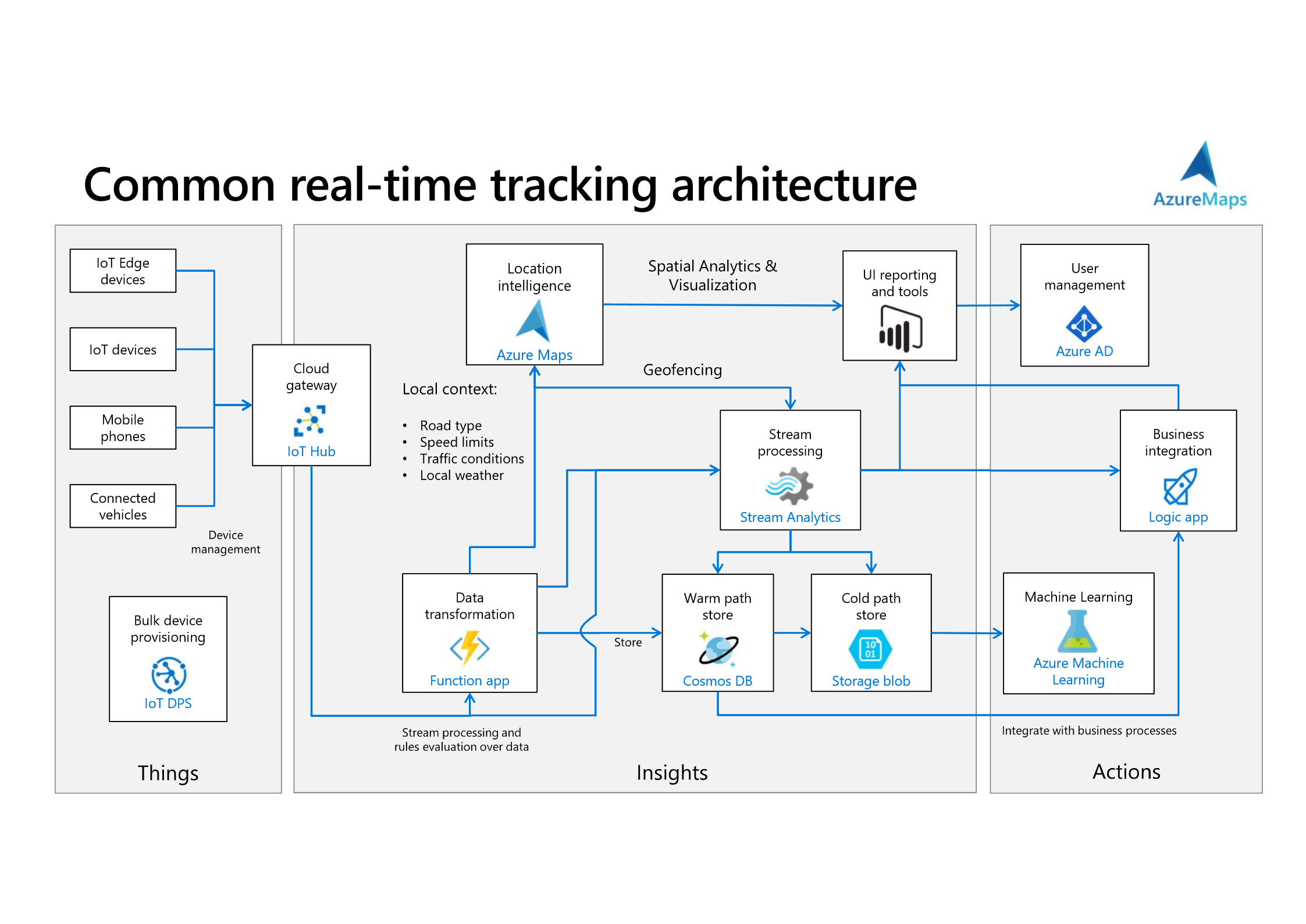
“Whatever you’re tracking, whether it’s an IoT device, a phone or a connected vehicle, all that can be done with Azure IoT,” he explains. “You pull all your sensor data and the location into Azure IoT Hub, which a messaging platform that can handle a ton of messages from every sensor you have. To get those sensors connected, the device provisioning platform allows you to connect thousands of devices very, very quickly. Then maybe you want to enrich that data and do some transformation; you can grab the road type, the speed limit and the weather conditions or the traffic level from Azure Maps so you get a better sense of the environment the data is coming from. You can do geofencing, either through Azure Maps or through Azure Stream Analytics (which has the same geofencing API). You can do machine learning on it. And then eventually you’re going to want a report or a dashboard, and we can help with the spatial analytics and visualisation.”
Mixing and matching those Azure services gives developers a lot of flexibility to build a custom solution, but if you want to try out a quick proof of concept or you don’t have a developer available to work on it, you can build a real-time tracking system with location intelligence without needing to write any code using IoT Central (which puts a friendly front end around the IoT Hub provisioning and management tools).
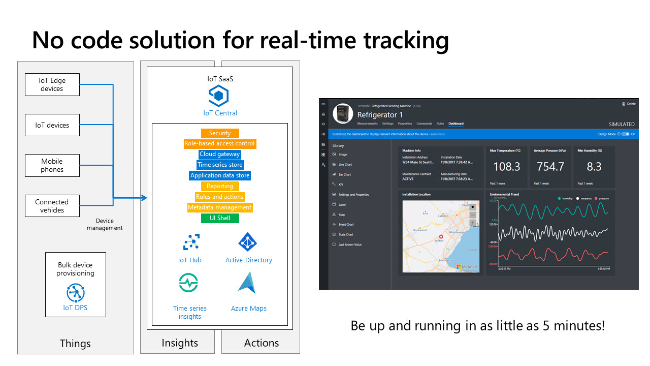
That doesn’t give you as many of the features of Azure Maps; you can see devices as a pushpin on the map, or if it’s a mobile device you can see the path on the map of where it’s been, but the benefit is how quickly you can get it working. “You can use any of the same devices and you can be up and running in as little as five minutes,” he says.
The definition of the Internet-connected Things that Azure Maps can help you with also goes beyond the traditional sensors and controllers. There are new features in the Azure Maps Web SDK for customers who are using it in conjunction with drones, which are starting to become part of mobile IoT setups. The same extruded polygons used to draw buildings, where you take a polygon and stretch it vertically, can now be raised off the ground.
“If you want to do geofences for drones and you’re looking at permitted airspace for them, you need to draw a box or a disk up in the air for that airspace,” Brundritt explains. As well as controlling its flightpath, that means a drone could trigger the same kinds of alerts as earthbound IoT devices, thanks to Azure Maps.
Learn more about Azure Maps and IoT – watch the recording of our webinar “The Location of Things” on our YouTube channel here
The Grey Matter mapping team are specialists in Azure, licensing, and maps. Their years of experience of working with ISVs and developers gives them a deep understanding of the requirements of building location-aware applications. Contact them directly to discuss your use case and get set up to start visualising your data on Azure Maps: +44 (0)1364 655 133 or email: mapping@greymatter.com
Contact Grey Matter
If you have any questions or want some extra information, complete the form below and one of the team will be in touch ASAP. If you have a specific use case, please let us know and we'll help you find the right solution faster.
By submitting this form you are agreeing to our Privacy Policy and Website Terms of Use.
Mary Branscombe
Mary Branscombe is a freelance tech journalist. Mary has been a technology writer for nearly two decades, covering everything from early versions of Windows and Office to the first smartphones, the arrival of the web and most things in between.
Related News
Intel oneAPI 2024.1 A Milestone Release
What’s new in Intel oneAPI 2024.1 The 2024.1 release of Intel® Software Development Tools marks a major milestone for developers AND the entire software industry: the Intel® oneAPI DPC++/C++ Compiler has become the first compiler to fully support the SYCL...
ISV Partner Day Shortlisted for CRN Sales & Marketing Award
ISV Partner Day has been shortlisted for "Best Customer Event" at the CRN Sales & Marketing Awards
Microsoft 365 and Azure Security Tools: Microsoft Intune
In the second video in our series of short videos discussing Microsoft 365 and Azure security tools and concepts, our Microsoft experts cover off all you need to know about Microsoft Intune! Intune is a robust cloud-based solution to safeguard...
Women in Tech: A New Era | Roundtable
Fri 21 June 2024 5:00 pm - 11:30 pm BST
Get ready to shake it off (and network like nobody’s watching) because we’re hosting an exciting exclusive Women in Tech event with ESET that you won’t want to miss out on. Join us and share feedback, experiences and insights with...