What's new from Build 2018 in Bing and Mapping Services
Blog|by Mary Branscombe|21 June 2018

Microsoft continues to take the technologies it developed for the Bing search engine and make them available as services that developers can use either for their own search tools, or to power features in apps.
New Bing APIs
The Bing Custom Search API announced last year is already used by a growing number of large customers like Intuit, Temple University and global banks to deliver customised, ad-free search results from the web on specific topics. (The Azure Search service uses the same Bing technologies but to index and rank your own content, rather than giving you a customised search engine for the public web, with the option of using Cognitive Services to enhance the indexing with features like OCR and entity recognition.)
The new version of the Bing Custom Search API adds custom autosuggest; Custom Autosuggest helps predefine automatic query suggestions for your content within selected domains. Users can also define their own suggestions on top of the suggestions Bing will provide for the domains that are a part of Active List. The Custom Autosuggest feature will help users complete their queries faster by adding intelligent type-ahead capabilities to your app or website. You can also use that to add relevant information that end users didn’t know to ask for, explains Gurpreet Singh Pall, Partner Director of Program Management for the Bing and Cortana Ecosystem. “We let you editorialise it. Say you launch a new product and people are looking for the old product and you want to show certain results on your site that are related to the new product, we let you do that in an editorial way.”
Custom image search lets you show relevant images from specific domains for specific search terms, so you can make sure only the official images are included.
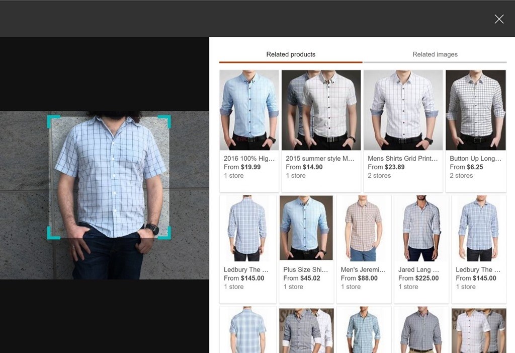
You can also use images as the input to a search query with the new Bing Visual Search API. Add that to a smartphone app and staff or customers can take a picture – which will be automatically cropped to the objects recognised in the scene – and use that to search for matching images.
It could search your product catalogue or support site to give them more information about something they’re thinking about buying or need help with, or help them find which aisle and shelf a product can be found on. It could identify plants for shoppers at a garden centre, or show recipes and calorie information for different kinds of food. Retail staff could use Visual Search to check returns or deliveries to make sure they’re products the store carries or to get instructions for shelving them. Wine app Delectable is using the new API to detect and recognise wine bottle labels in photos, so users can snap a picture of a wine to get reviews, ratings and other information about the wine. Or you could use it to check that the images customers upload to a service that lets them rent out their home or possessions are real photographs they’ve taken rather than a photograph they’ve downloaded from another website.

Use an image snapped in a smartphone app to search a product catalogue with Bing Visual Search (Source: Microsoft)
There are also administrative improvements to custom searches, like statistics of how many people are executing searches, for what terms, at what time of day, and where from, to help you understand what your customers are looking for and tweak the customisations you’ve applied to searches.
You can also pull information from Bing to incorporate in your apps and services with APIs like Text Analytics, which runs natural language processing over text to do sentiment analysis, key phrase extraction and now Entity Identification to recognise real world entities like people, places and organisations and link to relevant websites about them.
The new Project URL Preview creates captioned thumbnails as previews of web pages that you can show to users as part of their search results (it also flags or removes sites with adult content if you decide that’s not appropriate for your searches). Project Answer Search shows common facts and figures on the topics users are searching for; these are the same ‘instant answers’ you’d see at the top of a Bing results page and even include the multi-perspective answers to questions with complicated answers like ‘is coffee good for you?’ The ‘project’ tag indicates that these new APIs are both Cognitive Services labs previews – APIs that are still in early development.
Maps in action
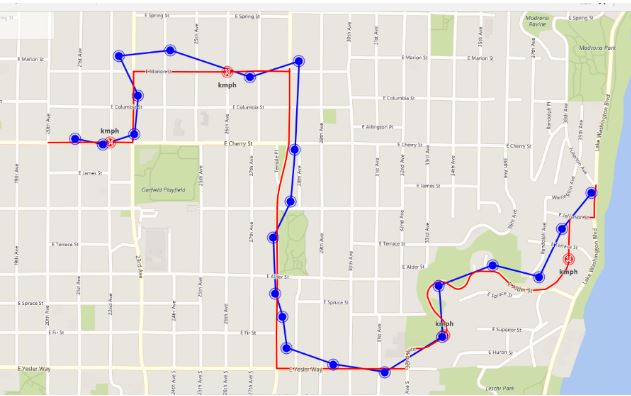
The Bing Maps APIs that were previewed last year have all now launched, with added features like ‘Snap To Road’ which lets you map a route and create a geotrail based on recording the position of a handful of locations along the way rather than needing to have the GPS on all the time (which uses up battery). You can then use this geotrail information to calculate the exact distance driven for mileage claims or to schedule vehicle maintenance, or to check if a driver stayed under the speed limit without needing power-hungry sensors running all the time.

The Snap To Road API converts GPS points of your tracked assets to a corresponding set of interpolated latitude and longitude co-ordinates of the nearest roads. (Image: Microsoft)
The open source Bing Fleet Tracking Solution that you can download from GitHub and run on Azure uses several of these APIs to power Android and iOS apps that can track vehicles and staff for small and medium sized companies. “We can tell you where this person is, if this person is inside the geofence, so you can redirect people as necessary,” explains Singh Pall. It’s ideal for a business like a small restaurant chain wanting to track delivery trucks that bring supplies from its warehouses as well as delivery drivers, he suggests. “Delivery people come and go, they have part-time jobs. With a more flexible workforce, businesses need a simple solution that doesn’t require expensive equipment or a lot of training.”
The mapping APIs connect to the Microsoft Graph, so you can use location information alongside business documents and databases in Office 365 which often have geographical details like addresses. The information stays in a customer’s own tenant – it’s not visible to other Office 365 tenants or even Microsoft – but it is available on other Microsoft services you use, like Dynamics 365, which is using the mapping APIs for features like helping you plan a schedule of deliveries or customer visits. “If I have four bakeries around town and I deliver my goods to a hundred outlets and each bakery specialises in something different, how do I optimise my route based on the orders? It takes traffic into account and we have it for walking, transit and biking because the courier who is travelling could be on a cycle or a motorbike or walking,” Singh Pall points out. The Distance Matrix API (which can handle up to 625 pairs) can optimise the delivery route based on the orders from each location.
There are more geo APIs coming in the future; an intriguing one that’s being developed as part of Microsoft’s AI for Earth project is a land use mapping API which uses image recognition to categorise the terrain shown in high resolution aerial photographs as roads, water, trees, grass, buildings and so on – even more accurately than the existing, official classifications for the same land. It’s currently in private preview but it’s a tantalising glimpse of mapping services that could tell you everything from how likely an area is to flood to how long it will take you to get there.
Our mapping specialists can help you create a Bing Maps trial key to get started, and discuss your use case. Call them on +44 (0)1364 655 133 or email: [email protected]
Check out the Bing Maps v8 Code Sample project and the Interactive SDK library.
Contact Grey Matter
If you have any questions or want some extra information, complete the form below and one of the team will be in touch ASAP. If you have a specific use case, please let us know and we'll help you find the right solution faster.
By submitting this form you are agreeing to our Privacy Policy and Website Terms of Use.
Mary Branscombe
Mary Branscombe is a freelance tech journalist. Mary has been a technology writer for nearly two decades, covering everything from early versions of Windows and Office to the first smartphones, the arrival of the web and most things in between.
Related News
Microsoft Copilot and E3/E5 promotions extended
Microsoft’s recently announced the extension of two of their ongoing promotions. You now have until 30 September 2025 to take advantage of these discounts. We’ll outline the two promotions below: Microsoft 365 Copilot Getting Started If you’ve been waiting for...
Secure Impact Microsoft 365 Security Assessment
Microsoft 365 Security Assessment The Microsoft 365 Security Assessment is a cloud-specific service that emphasises shared responsibility in SaaS. It evaluates the client’s cloud setup, focusing on identity security in hybrid environments. The service reviews various Microsoft tools and covers...
Secure Impact Penetration Tests
What is a penetration test? Before we dive into Secure Impact’s offering, it’s best to start at the beginning and explain what penetration tests are and why you need them. Watch the video below to get a high-level overview. How...
About Secure Impact
Secure Impact Bespoke consultancy that drives real cyber security outcomes In an industry that’s noisy, commoditised and compliance-driven, you need cyber security partners who can add value and create real outcomes for your organisation. Secure Impact (SI) offers world-class penetration...