Unlocking geospatial intelligence with Maps in Microsoft Fabric
News|by Jamie Carruthers|21 November 2025

Data alone doesn’t drive decisions. It’s context that turns numbers into action. Location intelligence brings that context to life. With Maps in Fabric, organisations can fuse geospatial analytics into their analytics stack, unlocking real-time insights that lead to smarter decisions and measurable business impact.
For technology teams, this isn’t just another feature update. It’s a step-change for industries where location matters - utilities, construction, sustainability, and more. As a Microsoft partner, we help you harness these capabilities to solve real challenges.
Why it matters: solving real pain points
Fragmented mapping workflows, siloed spatial data, and clunky custom imagery have slowed teams down. Scaling insights meant juggling too many tools.
The result? Delays, inefficiencies, and missed opportunities.
Maps in Fabric changes the game. By embedding geospatial capabilities directly into the Real-Time Intelligence workload, you get a single, unified platform for spatial analytics. No add-ons. No workarounds. Just seamless insight.
What’s new in Maps for Fabric?
Microsoft’s latest announcements at Ignite and Fabcon Europe introduce three standout features for solution builders:
- Bring your own imagery
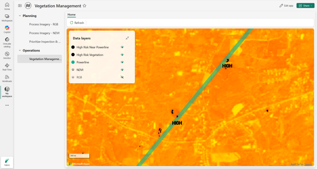
Import OneLake imagery and customer-specific raster datasets directly into Real-Time Intelligence. This means you can use up-to-date, analysis-ready imagery for tailored scenarios like utilities pinpointing high-risk zones, sustainability teams tracking land use, or vegetation management teams identifying where crews should be sent next. No more waiting for generic basemaps; now, your own data drives the insight. - Custom spatial layers
Add points, lines, and polygons with flexible labelling. Visualise assets, risks, and milestones in real time, whether you’re tracking construction progress, monitoring resource allocation, or comparing changes over time to catch delays before they impact the bottom line. Custom labels let you highlight what matters most, making it easier to act on spatial intelligence. - Org Apps integration
Scale mapping workflows across your organisation. Share dashboards, operational insights, and spatial intelligence without friction. With Org Apps, you can deploy mapping solutions at scale, ensuring everyone from field teams to decision-makers has access to the same real-time context. This streamlines collaboration and accelerates response.


Real-world impact
- Resource management
Utilities overlay fresh imagery with asset data to pinpoint outage risks and optimise crew assignments. - Construction monitoring
Weekly site imagery combined with milestone labelling helps identify delays early, keeping projects on track. - Land use tracking
Blend vegetation and land cover data with asset portfolios to support sustainability reporting and compliance.
Ready to explore?
Start experimenting with your own datasets today and discover how spatial intelligence can transform your operations.
As a trusted Microsoft partner, we deliver solutions that unlock the full potential of the Azure Maps ecosystem, from strategy to implementation. Let’s talk about integrating these capabilities into your workflows and delivering real business value.
Contact Grey Matter
If you have any questions or want some extra information, complete the form below and one of the team will be in touch ASAP. If you have a specific use case, please let us know and we'll help you find the right solution faster.
By submitting this form you are agreeing to our Privacy Policy and Website Terms of Use.
Related News
Be more productive: Microsoft 365 + Copilot
Undoubtedly, your team will be using AI in one form or another, whether it be for research, drafting emails, putting together PowerPoints, or collating data in Excel. But unless you’ve got oversight of the AI they’re using, their tools may be ineffective at best or even putting...
New changes to Visual Studio benefits: What you need to know
Microsoft is replacing legacy Visual Studio partner benefits with Visual Studio Enterprise Lite – and it’s going to change how your team access credits, licences, and tooling. What’s changing with Visual Studio Lite? From the introduction of Visual Studio Lite on 13 February 2026, you’ll no...
Strengthen your Microsoft Defender strategy with Sophos MDR
Cyber attackers aren’t slowing down – and they’re certainly not getting less sophisticated. Even with strong protections like Microsoft Defender in place, today’s human‑led attacks continue to slip through automated defences. That’s why more organisations are choosing to strengthen Microsoft...
The complete guide to the JetBrains AI ecosystem
AI is no longer a nice-to-have for development teams. It’s reshaping how you write, test and maintain code every day. JetBrains is one of the vendors pushing that shift furthest – and doing it directly inside the tools you already trust. JetBrains has evolved far beyond their productivity helpers like...