Location intelligence: powering real-time decisions at scale
Blog|by Jamie Carruthers|25 June 2026

How location intelligence powers real-time decisions at global events
Large-scale events don’t fail because of missing data.
They fail because no one can act on it fast enough.
That’s exactly how location intelligence powers real-time decisions in high-pressure environments. It turns disconnected data into clear, actionable insight.
Schedules, maps, routing data, weather, and crowd movement all exist.
But rarely together.
Teams are forced to switch between systems.
Decisions slow down, and visibility drops.
Location intelligence changes that. It connects place, movement, and live signals into a single, real-time view.
At the scale of events like World Cup 2026, where every second and every route matters, that shift is critical.
From data to decisions. What’s really happening
At global event scale, operations span continents, cities, and time zones.
What looks like a scheduling problem is something more urgent. It is a real-time decision challenge.
Teams need to answer instantly:
- What’s happening right now and where?
- How are people actually moving?
- Where are delays or risks building?
- What needs to happen next?
Disconnected systems cannot answer these questions quickly enough.
Location intelligence brings context to every data point. It turns fragmented inputs into something teams can act on.
How location intelligence powers real-time decisions
Real-time decision-making comes down to three things: context, timing, and clarity.
Location intelligence delivers all three by combining:
- Spatial data, including maps, routes, and geofences
- Live operational signals such as traffic, events, and movement
- Time-based data including schedules, sequencing, and time zones
The result is a connected, real-time operational view.
Instead of reacting after the fact, teams can:
- Adjust routes dynamically
- Manage crowd flow proactively
- Respond to incidents as they unfold
- Coordinate across multiple locations in real time
This is the difference between seeing what’s happening and controlling what happens next.
From maps to decision engines
There is a clear shift underway.
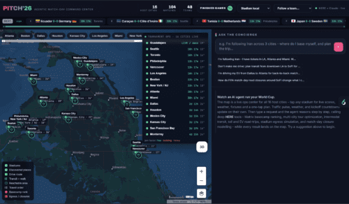
Passion projects like PITCH’26 show what happens when you stop switching between tools and start connecting the dots.
A modern, location-driven platform brings everything together:
- Match and event data
- Venue and spatial context
- Routing and traffic intelligence
- Time zone aware schedules
- Live operational insights
All in one place.
Instead of jumping between systems, teams get answers instantly:
- Which events are live or completed?
- What is happening around each location?
- Where should people or assets move next?
- How is timing shifting across regions?
This is where location intelligence moves beyond a visual layer. It becomes a real-time decision engine.
How location data drives real-world descision
Built for World Cup scale but not limited to it
In each case, the objective is the same – turning fragmented signals into a coordinated, real-time operational view.
The principles do not stop at sport.
Any environment where movement, timing, and coordination matter will benefit:
- Airports managing passenger flow
- Smart cities reducing congestion
- Logistics platforms optimising fleets
- Exhibitions handling footfall
- Emergency services responding to live incidents
The requirement stays the same. Connect data, surface insight, and enable action.
Building the right stack. Why flexibility wins
Delivering real-time decisions takes more than a single data source.
A multi-provider approach gives platforms the flexibility to scale, adapt, and perform under pressure.
HERE: Depth and precision
HERE Technologies brings the depth needed for complex, multi-location environments:
- High-quality global map data
- Advanced routing and traffic intelligence
- Rich geospatial context
It is a strong fit where accuracy and scale both matter.
TomTom: Speed and responsiveness
TomTom adds the speed modern platforms rely on:
- Real-time traffic data
- High-performance routing APIs
- Flexible, developer-friendly integration
It works well in dynamic environments where movement constantly changes.
Microsoft Fabric: Connecting everything
Microsoft's Maps in Fabric represent a major shift.
Location data is no longer separate from analytics. It becomes part of a unified data environment where spatial and operational data work together.
This enables:
- Real-time integration across systems
- Unified analytics with location context
- Faster, more informed decisions
For platform teams, this marks a move from disconnected tools to connected intelligence.
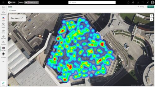
Maps in Fabric stadium geodata dashboard
What this means for platform builders
Expectations have changed.
Users do not want more dashboards.
They want clear answers in real time.
To deliver that, platforms need to:
- Build in location intelligence from the start
- Combine real-time and historical data
- Support multiple data and mapping providers
- Surface insight in context, not isolation
The competitive edge comes from how well systems understand and respond to the real world as it changes.
Turning insight into action
Expectations are changing.
Location intelligence is not just about seeing where things are.
It’s about understanding:
- What is happening
- Why it matters
- What should happen next
In high-pressure, high-movement environments, that difference is critical.
World Cup 2026 is just one example. The opportunity goes much further.
Why a specialist approach makes the difference
Getting value from location technology is not just about access. It is about applying it properly.
A specialist approach helps you:
- Choose the right mix of HERE, TomTom, and Microsoft technologies
- Integrate location intelligence into your platform architecture
- Align capabilities to real-world use cases
- Accelerate time to value with expert support
The result is a more connected, responsive, and scalable platform.
Turn insight into action with a location intelligence assessment
Understanding what location intelligence can do is one thing.
Knowing how to apply it to your platform is another.
Our location intelligence assessment helps you take the next step.
We’ll work with you to:
- Review your current data, systems, and architecture
- Identify where location intelligence can add the most value
- Recommend the right mix of technologies, including HERE, TomTom, and Microsoft
- Outline a clear path to implementation
So you can move from concept to confident execution.
Start with a location intelligence assessment. Talk to our team today.
Final thought
From disconnected data to connected context.
From static views to real-time decisions.
That’s the shift.
Location intelligence isn’t just a feature anymore. It’s the operating layer.