
How Maps in Fabric Empowers Businesses to Harness Location Data
News|30 September 2025
Microsoft Maps in Fabric, a feature just announced at FabCon Europe, makes real-time geospatial insights simple. Whether you're managing supply chains, tracking deliveries, or analysing a campaign's performance, understanding "where" adds powerful context to your data.
What makes Maps in Microsoft Fabric a game changer?
Maps in Fabric brings all your geospatial data - both static and real-time sources - into one intuitive platform. Best of all, you don't need to be a developer to uncover meaningful insights. Just connect your data, select your layers, and begin exploring - no code required.
Key features
- Unified View: Visualise both historical and real-time data, all within your existing Fabric workspace.
- Layered Insights: Combine multiple datasets—like sales by region, live order tracking, and in-store foot traffic—to see the bigger picture.
- Real-Time Monitoring: Instantly track events as they unfold, from logistics to marketing campaigns.
- Easy Sharing: Share geospatial reports and dashboards throughout your organization with just a few clicks.
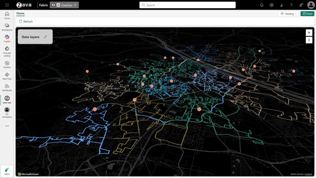
See real results, in real-time
Organisations using Maps in Fabric can unify historical records and real-time data streams to visualise global operations, monitor live orders, and analyse in-store activity—all without writing a single line of code. The result is faster, smarter decisions at every level.
Check out the most recent blogs from the Microsoft Fabric team that shows you how Microsoft Fabric is laying the foundation for AI-driven operations by visualising real-time location data and understand how organisations can unify historical records and real-time data streams to visualise global operations.
Here's why we recommend Maps in Fabric
Get started today
Ready to bring your data to life? Maps in Microsoft Fabric is now available in public preview. If you want to supercharge your location intelligence, contact us to discover how we can help you integrate Maps in Fabric and Azure Maps to meet your business needs.
Everything happens somewhere. Let us and Microsoft Fabric show you where your next opportunity is waiting.