Bing Maps 3D maps for MR plus new logistics API
Blog|by Mary Branscombe|17 June 2019

Microsoft brings real 3D maps to Mixed Reality
The maps in Bing aren’t just useful as a 2D control to use in apps and on websites; as augmented reality and VR become more popular, developers are looking to put maps into those experiences too. While primarily usage could be for a game, there are plenty of business applications: understanding the layout of a city to see how your new office or retail outlet will fit in, looking at the location for an industrial facility or investigating possible drone flight paths. Because so many developers were creating their own map content for HoloLens and Windows Mixed Reality headsets, often using Unity, the Bing Maps team created a map control for Unity to render the Bing 3D Maps that were previously only available for Windows Application developers.
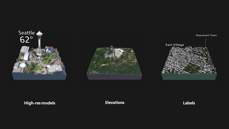
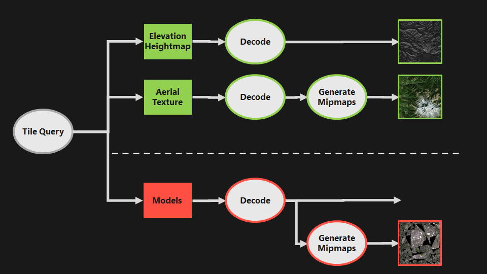
The Maps SDK has full terrain data for the entire planet, with high resolution imagery for some 400 cities including detailed mesh and texture models down to individual houses and features on the street. Outside of the detailed cities, worldwide elevation data and aerial or satellite photography is used which is useful for visualising natural feature areas or overviews. Labels for major cities can be displayed to help orient the user. The map uses a Mercator flat projection and has up to twenty zoom levels, each showing four times as much detail, so you can go from a view showing the world or a specific country, all the way down to individual houses on a street.

elevation data, and labels
Developers can pin their own custom objects to the map, whether that’s items in a game, pointers to the locations of your retail stores, the number of houses in a buyer’s price range that are on the market in an area, or text explaining something about a location. As users zoom in and out on the map, the objects can stay as individual items or be clustered together and shown as a number, so this stays efficient for large data sets. The scale of your pinned objects can be constant – if you’re pinning a custom pin with your logo on or some text about the location, you want those to stay readable at any zoom level – or they can scale with the world, so the model of your new building shrinks and zooms with the rest of the street.

Users will be able to fly over the 3D map, but developers can also animate the map to pre-program flight paths from one place to another; that can be a simple jump ‘as the crow flies’ or you can animate the camera position along a specific path if you want to give a guided tour or show what will be visible along a drone’s flight path. There are animated GIFs on the GitHub repo page.
To show developers what’s possible with the control, Bing Maps worked with the Microsoft MR Garage team behind the Outings app to create a mixed reality sample app where you can fly around a city and learn about landmarks and locations you might want to visit. The Bing Maps team showed that this application runs on any consumer Windows MR Headset by demonstrating it at Build 2019 running on a Surface Book 2 with a Samsung Odyssey Plus. There are also more features planned for future versions of the Map Control, adding more geospatial services, more map data like labels and roads and support for more languages. You’ll be able to add your own textures to the map and potentially take map data offline for games that need to be installed or apps that are used in the field.

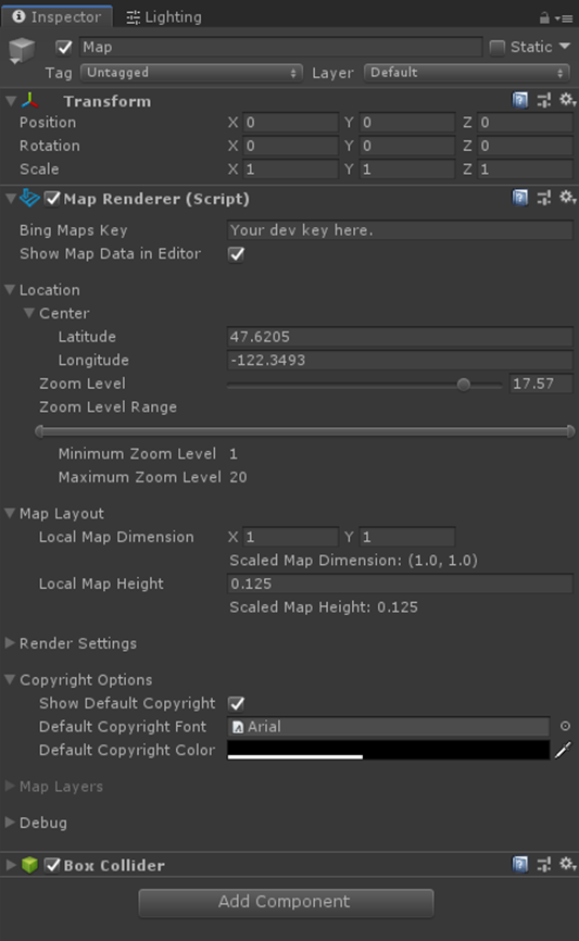
the location and zoom level of the initial map view
The Bing Maps Native SDK is also available in preview for Android and iOS, with the same 3D mapping, with road and aerial views, elevation data and buildings. You can create custom styles in the Maps style sheet editor that will work in mobile and Windows apps and on websites, to give you a custom consistent look across platforms.
Bing Maps new API for complex scheduling for multiple routes
Slightly more down to earth, the new Bing Maps Multi-Itinerary Optimization API ( called MIO by the Bing Maps team) is a REST service for creating efficient routes for multiple people; lorry and coach drivers, field support technicians, sales reps and anyone else who needs to get to multiple locations over multiple days and share jobs with other people, all of whom might be shift workers.
MIO builds on the waypoint optimisation feature Bing Maps introduced last year but handles more complex scenarios. It can route up to 10 people to 100 different waypoints, taking into account both the times and the locations that shifts start and end, as well as the priority of different jobs, how long someone will need to be on site, the opening times of the locations that have to be visited and predicted traffic.
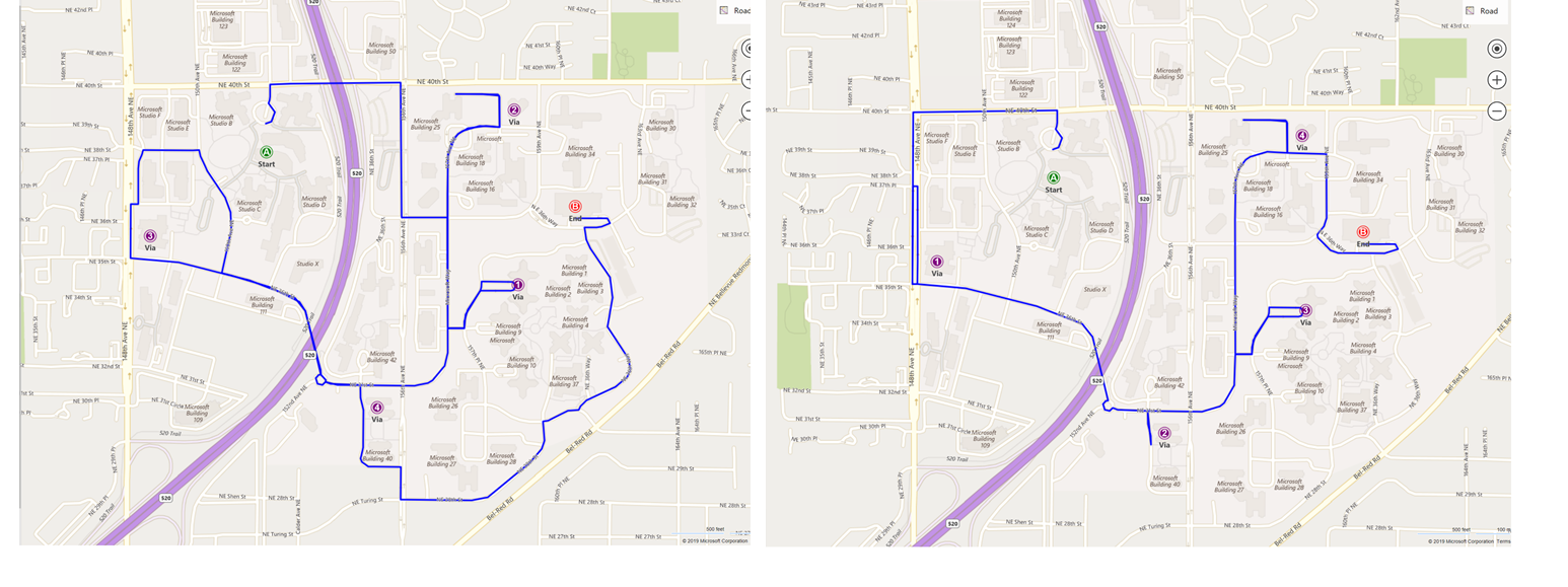
The API returns itineraries for all the travellers, with a full route for each person with departure times, locations, how long they’re expected to be on site, opening hours plus how far they’re going to travel and how long it should take. A real-world use case involves the shuttle buses dropping people off at different buildings on the Microsoft campus. The routes were optimised with the result of reducing a five mile route that took 32 minutes to a three mile route that took just 23 minutes.

If you need to monitor progress on those schedules during the day, you could combine the MIO result with the Bing Maps Fleet Tracking solution to check that people are where they’re supposed to be and offer dynamic rerouting if they’re falling behind because jobs turn out to be more complicated than expected.
Grey Matter is the authorised distributor of Microsoft Bing Maps for EMEA & APAC regions. Our mapping specialists can help you with your use case and provide licensing guidance and Services consultation. They can also help you get set up with a Bing Maps free trial key. Contact them at mapping@greymatter.com or call +44 (0)1364 655 133.
Contact Grey Matter
If you have any questions or want some extra information, complete the form below and one of the team will be in touch ASAP. If you have a specific use case, please let us know and we'll help you find the right solution faster.
By submitting this form you are agreeing to our Privacy Policy and Website Terms of Use.
Mary Branscombe
Mary Branscombe is a freelance tech journalist. Mary has been a technology writer for nearly two decades, covering everything from early versions of Windows and Office to the first smartphones, the arrival of the web and most things in between.
Related News
Intel oneAPI 2024.1 A Milestone Release
What’s new in Intel oneAPI 2024.1 The 2024.1 release of Intel® Software Development Tools marks a major milestone for developers AND the entire software industry: the Intel® oneAPI DPC++/C++ Compiler has become the first compiler to fully support the SYCL...
ISV Partner Day Shortlisted for CRN Sales & Marketing Award
ISV Partner Day has been shortlisted for "Best Customer Event" at the CRN Sales & Marketing Awards
Microsoft 365 and Azure Security Tools: Microsoft Intune
In the second video in our series of short videos discussing Microsoft 365 and Azure security tools and concepts, our Microsoft experts cover off all you need to know about Microsoft Intune! Intune is a robust cloud-based solution to safeguard...
Women in Tech: A New Era | Roundtable
Fri 21 June 2024 5:00 pm - 11:30 pm BST
Get ready to shake it off (and network like nobody’s watching) because we’re hosting an exciting exclusive Women in Tech event with ESET that you won’t want to miss out on. Join us and share feedback, experiences and insights with...