Azure Maps Creator
Blog|by Mary Branscombe|3 August 2020

Build your own indoor maps and routing for customers and staff using familiar Azure Maps capabilities.
At Microsoft Build 2020 earlier this year, Microsoft announced a new Azure Maps service for creating maps of your own private indoor and outdoor spaces – like offices, hospitals, factories, shopping centres, hotels, airports, resorts, and parks. Now available in preview as Azure Maps Creator, it’s initially aimed at spatial intelligence and map visualisation for indoor spaces where you can manage, monitor and track assets using floor plans and sensor data to get a dynamic map or do location analytics.
“We wanted to start helping customers create their own maps, keep them private, and give them full control of what they can do,” Roberto Lucchi, Senior Program Manager on Azure IoT, explained. “But we’re also part of Azure IoT and there’s a common desire not just for maps but for time series and analytics in general; there is this aspiration to be able to react to events as soon as possible.”
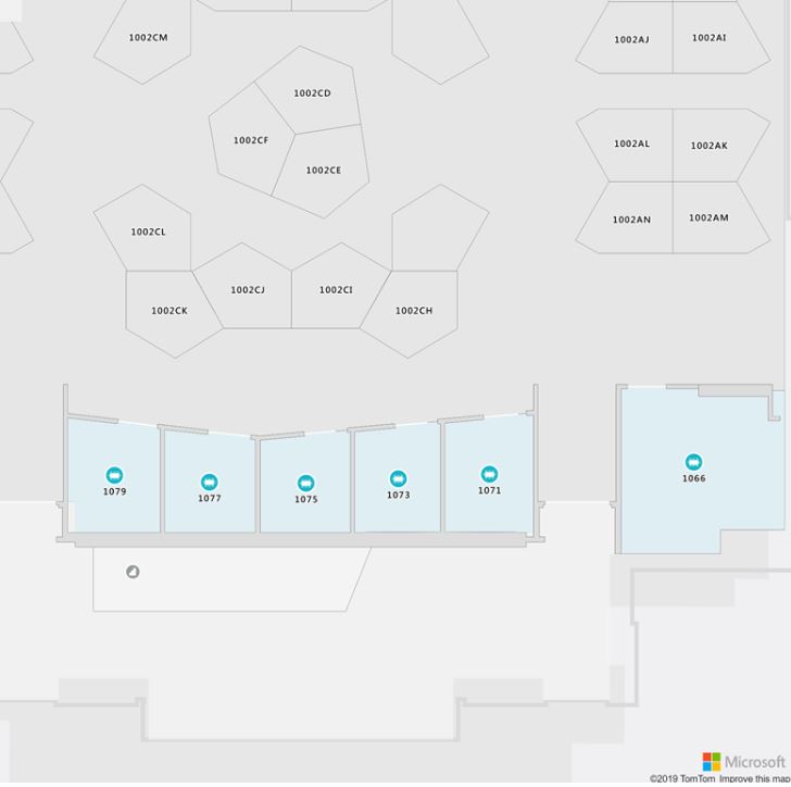
Indoor maps in action
If you have a sensor that’s running out of battery power or a gate or door being opened when it shouldn’t be, you want to get an alert to the right people, so they can take action quickly. “So we want to let people create their own maps and connect those with other spatial data feeds.”
Watch the recording of our Azure Maps webinar, The Location of Things: Smart Cities with Azure Maps, IoT and Digital Twins over on our YouTube channel, link here
The service is starting with indoor maps because more organisations have assets for those that will let them get started quickly.
With Azure Maps Creator you can upload the CAD floorplans (in DWG format) from construction or remodelling projects and convert them to maps that have rooms, walls, doors and windows, showing different levels, units, and buildings, or zones in a factory or warehouse that might not be physically separate. “You might have a single big space and logical sections for quality assurance or loading finished products, and you might have data sources that tell you that, say, the 10,000 components you have coming in today have arrived and you need to take action.”
If your plans are in other formats including the Revit models used widely by architects, PDF or even paper plans that need to be scanned in, partners like Archidata integrate with Maps Creator.
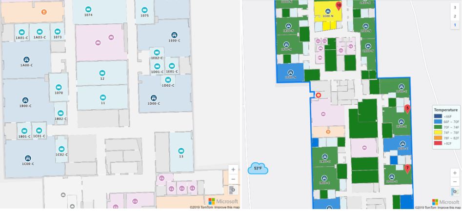
Then you can add more details (using GeoJSON) like what areas are covered by specific security cameras, where the wireless access points are and what strength of Wi-Fi signal is available in different areas of a warehouse, where staff can find a printer or fire extinguisher, or where coffee machines and water dispensers are that need servicing or refilling.
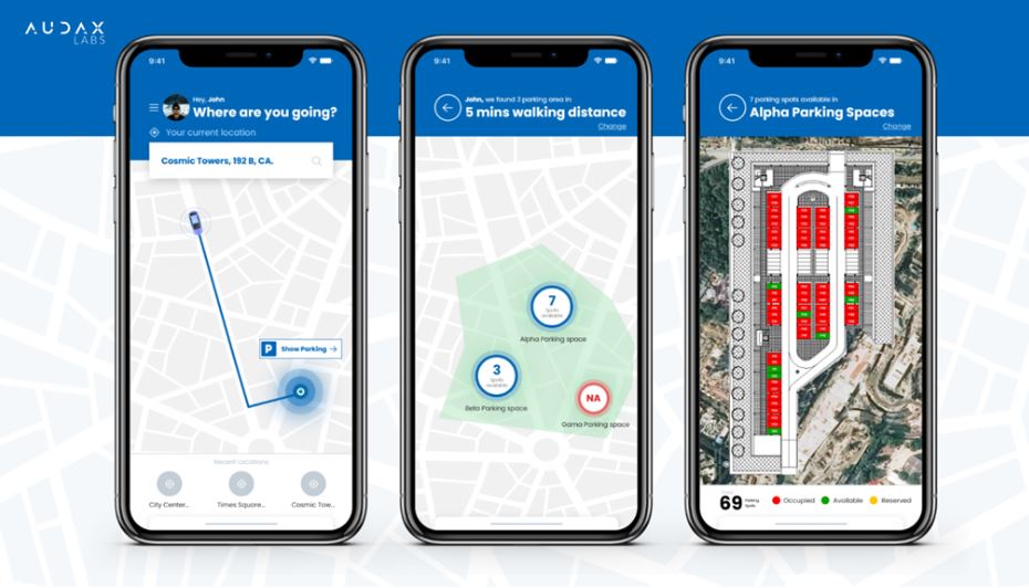
That stays as your own map data even when the map visualisation is delivered by the Azure Maps Render service (using vector tilesets and styles), but you can use it alongside the public Azure Maps data like routing, traffic and weather, so you could build an app that routes couriers to the right building entrance for their delivery that also includes traffic information for their trip, let visitors pre-book spaces in a parking garage for the time traffic suggests they will arrive, or analyse the patterns of shoppers coming to a store on foot or by car to understand safety risks when you’re planning delivery schedules.
Documentation:
Tutorial: Use Creator to create indoor maps
Dynamic styling for Creator indoor maps
If you’re monitoring sensor data, you can get a much richer picture by combining room temperature readings with weather predictions (maybe turning on the air conditioning before a room heats up if the forecast is for hot weather, or not turning on the heating if the outside temperature is about to climb).
Routing and navigation
You can also use spatial information internally for routing and planning, using the Azure Maps SDK Indoor module. The Web Feature Service lets you search for rooms and equipment in specific areas. There are multiple categories to mark how a space can be navigated: not just the pedestrian, car and cycle options that make sense for public, outdoor maps but options that businesses need to include like wheelchair and railcars. In future, the routing will also take into account what areas are wheelchair accessible, in much the same way outdoor routing covers whether commercial or personal vehicles can drive into an area. “There will be a similar mechanism to express wheelchair accessible [routes]: avoiding elevators or preferring ramps, no stair or cross floors…”
Routing could also cover how robots can navigate, using preferences and constraints. “You could have a preferred way for a robot to get to a specific destination that includes not having robots go in this given zone because it’s high traffic or it’s heavily used by children.”
Those optimisations can also take into account business preferences and whether it’s staff or customers navigating around the space. “If you’re making a kiosk app for an airport, if you were to route the fastest possible way to a gate you would probably skip the shops. There is typically a parallel corridor to the gates [for staff only], but the retail manager may want to suggest travellers go through the shopping area.”
You can use Azure Maps geofencing for alerts and automation with indoor maps but as people and devices move around inside a building, real-time navigation is often challenging. Windows 10 will soon include indoor location based on Wi-Fi in the geolocation API, which you could use to track down laptops that have been left in meeting rooms or to give staff live indoor navigation. The Azure Maps team is also working to incorporate the SLAM (Simultaneous Localization and Mapping) vision technology many robots use, and Azure Spatial Anchors which work on HoloLens, iOS and Android devices to enable mixed reality applications that know which room you’re in and what devices are available there.
“We’re agnostic to what indoor location technology you use and we’re building plug and play interfaces that can be used to send location,” Lucchi said. Indoor GPS platform SIRL, which can do precise indoor mapping with accuracy down to 12 inches, is using Azure Maps Creator to help supermarket customers in New York find where products are in the store – and suggest something else they might want in the same aisle.
As a preview product, Azure Maps Creator isn’t recommended for production but it’s functionally complete and ready to start developing with. “We already have early adopters,” he noted. “They can map their own space, they can build applications, they can do asset tracking: that’s all available now.”
Watch the recording of our Azure Maps “Location of Things” webinar on our YouTube channel here
For more information about Azure Maps, or help getting started with Azure, contact the Grey Matter mapping team: mapping@greymatter.com or direct, +44 (0)1364 655133.
Contact Grey Matter
If you have any questions or want some extra information, complete the form below and one of the team will be in touch ASAP. If you have a specific use case, please let us know and we'll help you find the right solution faster.
By submitting this form you are agreeing to our Privacy Policy and Website Terms of Use.